MHLFIT Public Projects
Lake Macquarie City-Wide Flood Warning System

As part of the Lake Macquarie City-wide Flood Warning System Project, MHL was commissioned by Council to develop the Lake Macquarie Flood Warning System. The system utilises near real-time data from rainfall and water level monitoring stations as well as real-time catchment hydrology modelling and flood level prediction. This project is supported by the NSW Government and the Federal Government through the Natural Disaster Resilience Program.
The Lake Macquarie Flood Warning System provides flood alert and decision support information that contributes toward minimising the loss of life and damage to property in the event of a flood. Alarm messages are used in conjunction with BoM weather forecasts and Flood Warnings to alert emergency response actions of SES and Lake Macquarie Council such as the closure of roads and issuing of evacuation notices to residents on vulnerable properties.
Water level predictions provide additional information about imminent flood behaviour including predicted peak levels and time of peak information at the modelled locations in the Lake Macquarie catchment. This provides decision support and helps to prioritise the deployment of emergency response resources. The public web-portal interface provides a display of near real-time conditions and flood information to assist residents in preparing for a flood emergency.
The web-portal includes the following features:
- Interactive map and plot featuring latest rainfall and water level data
- Historical data interactive plotting
- Dora Creek predictive model results. Authorised user section displaying additional 12-hour water level predictions.
- Intensity Frequency Duration (IFD) output for latest data
- Information about local flood behaviour, flood safety and emergency contacts.
Hornsby Shire Council Hawkesbury Watch

Hawkesbury Watch provides daily reports on swimming conditions, estuary health, water quality, algal blooms and interactive access to data. Hawkesbury Watch is unique to Australian estuaries - using remote monitoring buoys, Hawkesbury Watch provides real time information on estuarine conditions. This information is analysed and presented in innovative web visualisations to inform the community on swimming conditions and daily health reports.
A key innovation of Hawkesbury Watch is the ability to autonomously monitor the estuary. Most estuaries are monitored with grab samples which are analysed in a Laboratory and reported at a later date. These sampling programs utilise staff and generally operate with samples being collected once a month. Such programs are resource intensive and the low frequency of the sample collection often means questions regarding estuarine processes are left unanswered. Using automonous technologies to monitor the estuary allows the generation of high frequency data sets. Hawkesbury Watch collects data every 15 minutes, creating 96 data points a day. From this Council and the public can gain a greater understanding of estuarine processes, even night time dynamics, that were previously impossible to capture. These understandings then inform algal bloom management and reporting on estuarine health and swimming conditions. Further, this data is reported in near real-time and, like a weather report, is of most interest to the community who want to know current conditions as opposed to what happened several days ago.
Floods Near Me NSW

Floods Near Me (FNM) is a NSW flood warning and information application modelled off the success of the Fires Near Me app developed by the NSW Rural Fire Service. FNM has been developed by NSW Public Works Advisory (PWA) in conjunction with Manly Hydraulics Laboratory using State Emergency Management Projects (SEMP) grant funding to provide a single geo-specific information service that customers can use to view flood information, road closures and flood warnings throughout NSW.
The app consolidates near real-time data from the Bureau of Meteorology, WaterNSW, Manly Hydraulics Laboratory, NSW State Emergency Service, Transport for NSW and local councils in a single location. The app acts as a hub of information providing timely warnings and observations to those who require it. FNM also facilitates user access to the relevant authorities who are able to provide further information on flooding in their area. It is designed to have multiple functional uses for people travelling throughout NSW as well as those who reside in flood affected areas.
Some current features of the app include:
- User's current location or dropped pin
- Road closed and water over road locations
- Observed river gauge heights with interactive graphs
- Compare, rename or create favourite river gauges
- Flooded river sections (based on Minor, Moderate and Major flood levels)
- Flood Watch and Flood Warning information from BoM
- Evacuation Warning, Evacuation Order and All-Clear areas from SES
Lake Innes Water Quality Monitoring
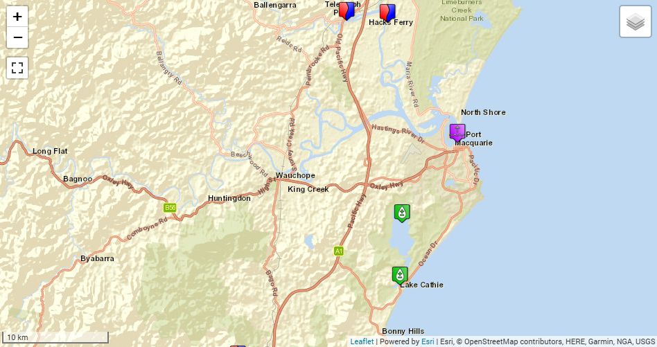
Port Macquarie Hastings Council (PMHC) is developing a Coastal Management Program, which includes monitoring and reporting of water level and water quality within Lake Innes. PMHC, the Department of Climate Change, Energy, the Environment and Water (DCCEEW), the NSW Department of Primary Industries and Regional Development - Fisheries, and the NSW National Parks and Wildlife Service have collaborated to fund the commissioning (August 2025) and maintenance of the Lake Innes water level and water quality monitoring station.
The PMHC Lake Innes Water Quality web portal includes an interactive map and plots featuring the latest water quality, rainfall and water level data, and interactive plotting and download of historical data. The stations presented are a mix of PMHC and DCCEEW stations. All data is presented in Australian Eastern Standard Time and is recovered directly from the instruments. For quality controlled data please submit a Data Request.